
Tornado Threat Rising for Sunday Across St. Louis, Columbia and Springfield as Forecasters Warn a Few Strong Tornadoes Are Possible
The tornado threat is increasing for tomorrow, Sunday June 21, 2026, across a wide stretch of the central United States, with St. Louis, Columbia and Springfield, Missouri sitting directly in the highest risk zone. Forecasters say a few strong tornadoes are possible depending on how the morning round of storms evolves, and the region should expect a very active day of severe weather.
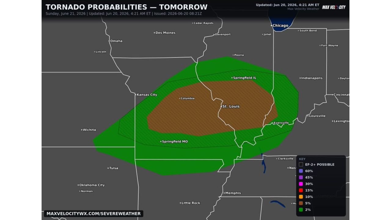
What the Tornado Probability Map Is Showing
According to the updated outlook released at 4:21 AM ET on June 20, the tornado probability map for Sunday shows two distinct risk zones spreading across the central Plains and Midwest:
- Brown Zone (15% tornado probability): The highest risk corridor, covering St. Louis, Columbia and Springfield, Illinois, along with the surrounding area. This zone carries the greatest concentration of risk for strong tornadoes rated EF-2 or higher.
- Green Zone (2% tornado probability): A much broader surrounding area extending from Kansas City and Wichita in the west, up through Chicago, Peoria and Des Moines in the north, and out toward Indianapolis, Louisville and Memphis in the east and south.
The map also notes that EF-2 or stronger tornadoes are possible within the hatched portions of the outlook, reinforcing that this is not expected to be a minor severe weather day.
Why Tomorrow Could Get Dangerous Quickly
Forecasters say the outcome of tomorrow’s severe weather largely depends on how the morning round of storms evolves. This is a critical detail because the behavior of early storms often determines how unstable and primed the atmosphere becomes for stronger, more organized storms later in the day.
If conditions develop the way forecasters are currently tracking, the region could see:
- A few strong tornadoes, potentially reaching EF-2 strength or higher
- An active and fast-evolving severe weather day across the entire region
- Conditions serious enough that a live stream coverage is likely from storm trackers monitoring the event in real time
Cities and Areas Most at Risk Sunday
Based on the current outlook, residents in the following areas should pay close attention to forecasts throughout the day Sunday:
- St. Louis, Missouri
- Columbia, Missouri
- Springfield, Missouri
- Springfield, Illinois
- Kansas City, Missouri
- Evansville, Indiana
- Peoria, Illinois
What You Should Do to Prepare
With forecasters already flagging Sunday as a likely very active severe weather day, residents across the highlighted region should begin preparing now rather than waiting until storms are already developing. Recommended steps include:
- Identify your safe shelter location ahead of time, ideally an interior room on the lowest floor
- Charge your phone and any backup power banks the night before
- Turn on weather alert notifications so you are notified the moment a warning is issued
- Avoid unnecessary travel during the afternoon and evening hours if storms are actively developing
- Monitor real time updates throughout the day at the NOAA Storm Prediction Center
This is a developing forecast and conditions may shift as Sunday approaches, so checking for updates throughout the day will be important for anyone in the highlighted risk zones.
Want more breaking weather updates and news that affects your community? Visit Bktoday.org for daily updates and never miss a story that matters.