
Forecasters Call Sunday a ‘Certainly Hard Forecast’ as Machine Learning Model Shows High Severe Storm Probability Stretching From Kansas to the Ohio Valley
Sunday’s severe weather setup is proving difficult to pin down even for experienced forecasters, with one meteorologist describing it simply as “certainly a hard forecast.” A new Day 2 machine learning severe weather probability model, valid for June 21, 2026, shows a large and uncertain zone of elevated severe storm risk stretching across the central United States.
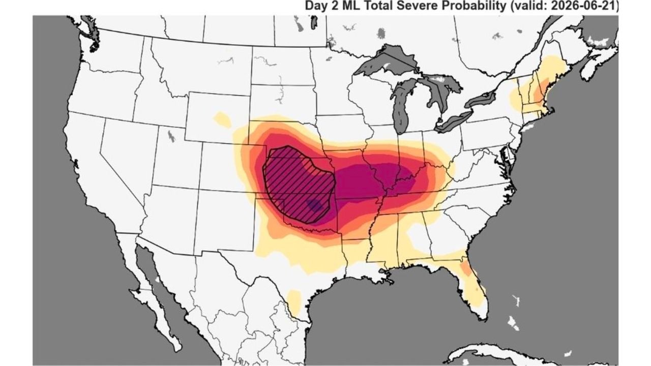
What the Machine Learning Model Is Showing
This particular forecast tool uses machine learning to calculate total severe weather probability, combining multiple atmospheric variables into a single probability map rather than the traditional categorical risk levels. According to the model, the highest probability zone, shown in deep purple and hatched, is centered over Kansas and extending into Missouri, indicating the greatest concentration of severe weather risk for Sunday.
Surrounding that core area, a broader moderate to high probability zone, shown in red and orange, extends across a much wider footprint stretching from:
- Eastern Kansas and Missouri
- Across Illinois, Indiana and Kentucky
- Into the Ohio Valley region
- Down toward Arkansas, Mississippi and Alabama
A lighter probability zone, shown in yellow, extends even further outward, reaching toward the Gulf Coast and parts of the Northeast, including portions of New England.
Why This Forecast Is So Difficult to Pin Down
Calling a forecast “hard” is a meaningful statement coming from meteorologists who track severe weather daily. It typically signals that multiple competing factors are creating uncertainty in exactly where, when, and how intense storms will become.
This uncertainty lines up directly with concerns already raised about Sunday’s setup, particularly around how the morning storm complex behaves and where it tracks. As covered in earlier forecasts, the placement of morning convection could significantly change how the atmosphere destabilizes through the afternoon, which is likely a major contributing factor to why this forecast is proving so challenging to lock down with confidence.
A Wide Swath of the Country Should Stay Alert
What makes this particular outlook notable is just how broad the affected area is. Unlike a typical severe weather day that might be confined to one or two states, Sunday’s probability map shows elevated risk stretching across more than a dozen states, from the central Plains through the Mississippi Valley and into the Ohio Valley and even touching the Northeast.
States and regions that should be paying close attention to forecast updates include:
- Kansas and Missouri (highest probability zone)
- Illinois, Indiana and Kentucky
- Arkansas, Mississippi and Alabama
- Ohio Valley region
- Parts of the Gulf Coast
- Portions of New England
What This Means Heading Into Sunday
When forecasters openly acknowledge a forecast is difficult, it is often a signal that conditions could shift significantly in either direction as new data comes in. Residents across the highlighted zone should not assume the picture is finalized and should continue checking for updates as Sunday approaches, rather than relying solely on today’s outlook.
Given that this broad uncertainty zone overlaps with areas already flagged for tornado risk and significant flooding on Sunday, this reinforces that the region is facing a potentially complex and high-impact severe weather day.
Stay Weather Aware Through the Weekend
With so much still depending on how Sunday’s atmosphere evolves, residents across the central and eastern United States should:
- Continue monitoring forecast updates throughout Saturday and into Sunday morning
- Have a shelter plan ready regardless of exact storm timing
- Keep weather alerts active on mobile devices
- Follow updates from the NOAA Storm Prediction Center as the picture becomes clearer
This is an evolving forecast, and the difficulty meteorologists are having in nailing down exact details is itself a sign that residents across a wide region should stay prepared for rapidly changing conditions.
Want more breaking weather updates and news that affects your community? Visit Bktoday.org for daily updates and never miss a story that matters.