
Flood Watches Issued From Eastern Kansas to Central Indiana as Sunday Rainfall Could Reach 1 to 3 Inches With Springfield Illinois Facing a 99 Percent Chance of Heavy Rain
On top of Sunday’s growing tornado threat, a separate and equally serious concern is developing across the same region. Flood watches have been issued from eastern Kansas to central Indiana as forecasters warn that scattered to widespread rainfall totals of 1 to 3 inches are expected Sunday, with even heavier amounts possible in certain areas.
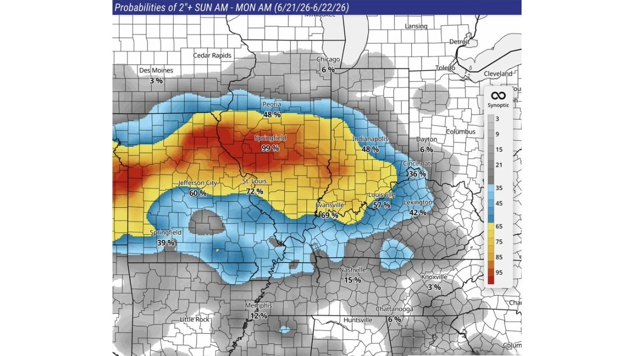
Where the Heaviest Rain Is Expected
According to flooding probability data covering Sunday morning through Monday morning (June 21 to June 22, 2026), the chance of receiving 2 inches or more of rain varies dramatically depending on location. Here is the breakdown across the region:
Extreme Risk Zone (90 percent or higher):
- Springfield, Illinois: 99 percent
Very High Risk Zone (60 to 89 percent):
- St. Louis, Missouri: 72 percent
- Evansville, Indiana: 69 percent
- Jefferson City, Missouri: 60 percent
High Risk Zone (40 to 59 percent):
- Peoria, Illinois: 48 percent
- Indianapolis, Indiana: 48 percent
- Louisville, Kentucky: 57 percent
Moderate Risk Zone (30 to 39 percent):
- Cincinnati, Ohio: 36 percent
- Lexington, Kentucky: 42 percent
- Springfield, Missouri: 39 percent
Lower Risk Zone (Under 20 percent):
- Nashville, Tennessee: 15 percent
- Memphis, Tennessee: 12 percent
- Chicago, Illinois: 6 percent
- Knoxville, Tennessee: 3 percent
Why This Flooding Threat Is So Serious
A nearly 99 percent probability of significant rainfall in Springfield, Illinois is an extremely high confidence forecast, leaving very little uncertainty that the area will see substantial flooding impacts. Combined with the severe thunderstorm and tornado threat already in place for the same Sunday timeframe, this creates a layered and compounding hazard for residents across the region.
Heavy rainfall falling on top of already saturated ground from severe thunderstorm activity can lead to:
- Rapid and dangerous flash flooding
- Overflowing creeks, streams and rivers
- Flooded roadways, especially in low-lying areas
- Compromised storm drainage systems unable to keep up with rainfall rates
The Double Threat Facing Central Missouri and Illinois
What makes Sunday particularly dangerous is that the same communities facing the highest tornado risk are also facing the highest flooding risk. St. Louis, Columbia, and Springfield, Illinois sit at the center of both hazard zones, meaning residents in these areas need to prepare for two very different but equally serious threats occurring simultaneously.
What Residents Should Do to Prepare
With both severe thunderstorms and significant flooding expected, residents across the affected corridor should take the following precautions ahead of Sunday:
- Avoid driving through flooded roadways under any circumstances, even if the water looks shallow
- Move vehicles to higher ground if you live in a known flood-prone area
- Clear gutters and storm drains around your property where possible
- Keep important documents and valuables in waterproof or elevated storage
- Monitor both flood watches and severe weather alerts throughout the day, not just one or the other
- Stay updated through the NOAA Storm Prediction Center for the latest severe weather and flooding guidance
This is shaping up to be a multi-hazard event, and residents should treat both the tornado threat and the flooding threat with equal seriousness heading into Sunday.
Want more breaking weather updates and news that affects your community? Visit Bktoday.org for daily updates and never miss a story that matters.