
Latest Forecast Model Shows Central and Southern Illinois Could Stay Clear of Morning Storms Sunday, Setting the Stage for Strong Tornado Producing Supercells
A new wrinkle has emerged in Sunday’s developing severe weather forecast for Illinois. The latest NAM weather model run suggests that Central and Southern Illinois could largely escape Sunday’s morning thunderstorm complex, a development that forecasters say may actually increase the risk of strong tornadoes later in the day.
Why the Morning Storms Matter So Much
Forecasters say there is still uncertainty regarding the exact placement of Sunday’s morning Mesoscale Convective System (MCS), which is essentially a large cluster of thunderstorms that often forms overnight or in the early morning hours. Where this system tracks and how much of the state it covers can dramatically change the outcome for the rest of the day.
According to the latest model run, most of Central and Southern Illinois is now projected to remain untouched by morning convection. That detail matters more than it might seem at first glance.
Why Avoiding Morning Storms Could Make the Afternoon More Dangerous
When morning storms move through an area, they typically leave behind cloud cover and stabilize the atmosphere, often reducing the severe weather threat for the rest of the day. If Central and Southern Illinois avoid that morning activity entirely, the atmosphere there remains primed and undisturbed, allowing it to fully destabilize under afternoon heating.
The latest model data shows this scenario developing into semi-discrete supercells forming in a highly-sheared environment, conditions that are specifically supportive of strong or violent tornadoes.
In simple terms, the very thing that might sound like good news, missing the morning storms, could actually set the stage for a more dangerous afternoon and evening across the region.
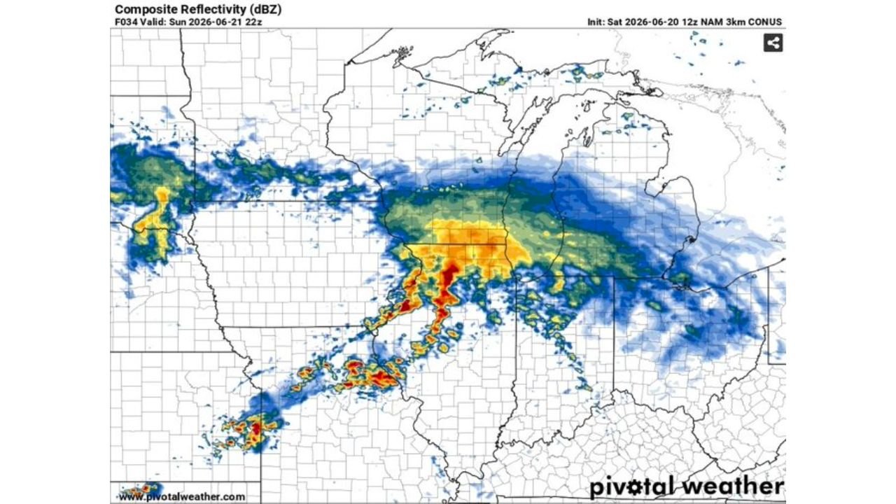
What the Radar Model Is Showing
The composite reflectivity forecast model, valid for Sunday June 21, 2026 at 22z (5 PM CDT), shows a large complex of storms stretching across the Midwest, with the most intense activity, shown in red and orange, concentrated over portions of Missouri, Illinois, and extending toward Indiana.
This visual lines up directly with the tornado probability and flooding threats already in place for the same region on Sunday, reinforcing that this storm system carries multiple compounding hazards beyond just tornado risk.
Another Potentially Major Setup Taking Shape
Forecasters are being direct about what this means. As one meteorologist put it, this could be “another potentially big setup”, and the outcome will largely be determined by how morning convection in Illinois plays out.
This adds yet another layer of uncertainty to an already complex forecast, meaning residents across Illinois and surrounding states should continue monitoring updates closely as Sunday approaches, since small shifts in the morning storm placement could meaningfully change the risk level by afternoon.
What This Means for Illinois Residents
Given the combination of:
- A possible tornado threat upgrade if morning storms stay south or west of Central Illinois
- An already forecasted flooding threat with rain totals up to 3 inches
- Highly-sheared atmospheric conditions supportive of strong tornadoes
Residents across Central and Southern Illinois should treat Sunday as a high-impact weather day regardless of how the morning unfolds. Conditions are evolving and forecasters are watching closely for updates throughout the morning hours.
Stay Prepared and Stay Informed
With so much still depending on how the morning storms behave, now is the time to finalize your safety plan rather than wait and see:
- Identify your shelter location ahead of time
- Keep devices charged and weather alerts active
- Avoid unnecessary travel Sunday afternoon and evening if storms are developing
- Continue checking updates throughout the morning, since forecasts could shift significantly
- Monitor real time data through the NOAA Storm Prediction Center
This is a rapidly evolving forecast, and the difference between a moderate severe weather day and a major tornado outbreak may come down to exactly where Sunday morning’s storms track.
Want more breaking weather updates and news that affects your community? Visit Bktoday.org for daily updates and never miss a story that matters.