
Strengthening Supercell With Increasing Rotation Moving Toward Marion Illinois and Could Become Capable of Producing Tornadoes, Large Hail and Damaging Winds
A strengthening supercell thunderstorm with increasing rotation is currently moving in the direction of Marion, Illinois and is being watched closely by forecasters for further intensification. The storm is already showing signs of organizing within a favorable severe weather environment, making it one of the most closely monitored cells across southern Illinois this afternoon and evening.
What This Storm Could Produce
As the supercell continues to strengthen and organize, forecasters warn it may become capable of producing:
- Tornadoes
- Large hail
- Damaging wind gusts
The key phrase here is “may become capable,” meaning this storm has not yet produced these hazards but is trending in a direction that makes all three possible if strengthening continues at its current pace.
What the Radar Is Showing Right Now
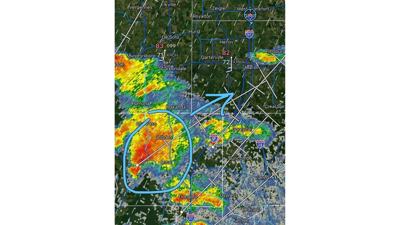
Live radar imagery shows the supercell currently centered near Anna, Illinois and Cobden, with a clear circulation signature highlighted by the blue circle on the radar image. The storm is tracking northeast, directly toward the Marion and Carterville area based on its current movement.
Radar data shows intense red and orange returns at the core of the storm near Anna, indicating extremely heavy rainfall and strong updrafts actively developing within the cell. The storm track arrow clearly points the circulation toward Marion as the next significant community in its path.
Nearby atmospheric readings are also notable, with dewpoint values in the low 80s near De Soto and Carterville indicating an extremely humid and unstable airmass feeding directly into the storm, providing it with the energy it needs to continue strengthening.
Communities That Need to Take Action Right Now
Based on the storm’s current location and northeast track, the following communities are in the most immediate path and should be preparing to shelter now:
- Anna, Illinois
- Cobden, Illinois
- Carbondale, Illinois
- Murphysboro, Illinois
- Carterville, Illinois
- Marion, Illinois
- Herrin, Illinois
- West Frankfort, Illinois
- Pittsburg, Illinois
- Creal Springs, Illinois
Why This Storm Deserves Serious Attention
This supercell is showing signs of strengthening within a favorable severe weather environment, which forecasters specifically called out as a reason to treat this cell as a priority storm. When a storm is actively intensifying inside an environment already primed for severe weather, the potential for rapid escalation from a thunderstorm to a tornado-producing supercell is very real and can happen quickly.
Residents in and around the Marion area should not wait for a warning to be issued before preparing. By the time a warning is issued, the storm may already be on top of you.
What You Should Do Right Now
If you are in southern Illinois, particularly in the communities listed above:
- Identify your shelter location immediately, on the lowest floor of a sturdy building away from windows
- Do not wait for a tornado warning before moving to shelter if the storm is approaching
- Keep weather alerts active on your phone at all times
- Stay off the roads in the path of this storm
- Monitor real time conditions through the NOAA Storm Prediction Center
This is a rapidly developing and potentially dangerous situation. Stay weather aware and be ready to take action immediately if warnings are issued for your area.
Want more breaking weather updates and news that affects your community? Visit Bktoday.org for daily updates and never miss a story that matters.