
Flooding Emergency Unfolding Across Memphis, Jackson and Central Arkansas Today as WPC Issues Moderate Flood Risk With Storms Hammering the Same Towns Hour After Hour
Memphis, TN and Central Arkansas are facing a dangerous flooding emergency today as the Weather Prediction Center has issued a Moderate flood risk, their second-highest category, across parts of Arkansas, Tennessee, and Mississippi. Forecasters are warning that repeatedly training storms combined with already saturated ground are creating a rapidly worsening situation across the region, with rain having nowhere to go but the roads and low spots.
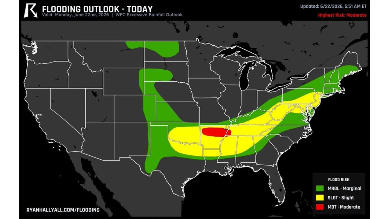
Where the Highest Flood Risk Is Concentrated
According to the flooding outlook updated at 5:51 AM ET on June 22, 2026, the risk zones break down as follows:
- Moderate Risk (Red Zone): The most dangerous area centered over the Memphis to Jackson corridor and into central Arkansas, where the flood threat is most concentrated and immediately dangerous
- Slight Risk (Yellow Zone): A broader surrounding area stretching from central Arkansas and Tennessee eastward through Kentucky, Virginia and into the Mid-Atlantic and Northeast
- Marginal Risk (Green Zone): An even wider footprint extending across much of the central and eastern United States
Why This Flooding Situation Is So Dangerous
The core issue driving today’s extreme flood risk is something meteorologists call training storms, meaning storms are repeatedly developing and moving over the exact same locations hour after hour rather than spreading across a wider area.
This creates a scenario where:
- The same towns receive rainfall continuously rather than in a single passing storm
- Ground that was already soaked from recent storms has no ability to absorb additional moisture
- Rain has nowhere to go except onto roads, into low-lying areas, and into drainage systems that are already overwhelmed
The Corridor That Needs to Be on High Alert Today
The heart of today’s flood threat runs from around Memphis, Tennessee down toward Jackson, Mississippi and over into central Arkansas. This is where the Moderate risk designation applies and where the most dangerous flooding conditions are expected to develop and persist throughout the day.
Communities in and around this corridor should be treating today as a high-impact flooding day, not a routine rainy day.
A Critical Warning for Anyone Driving Today
Forecasters issued a direct and urgent warning for anyone on the roads across the affected region today. If you encounter water crossing a road, do not drive into it under any circumstances.
“You can’t tell how deep it is,” forecasters warned, and that uncertainty is exactly what makes flooded roadways so deadly. Just six inches of fast-moving water can knock a person down, and twelve inches of moving water can carry away a small vehicle. Roads that appear passable can be hiding dangerous depth beneath the surface.
Anyone traveling across Arkansas, Tennessee or Mississippi today should:
- Give yourself significant extra time to account for road closures and detours
- Never drive into water crossing a road regardless of how shallow it appears
- Turn around immediately if you encounter flooded roads
- Avoid low-lying areas near creeks, streams and rivers that may be rising rapidly
- Monitor real time updates through the NOAA Weather Prediction Center
Today’s flooding threat is serious, localized, and driven by conditions that are not expected to improve quickly given how saturated the ground already is across the affected region.
Want more breaking weather updates and news that affects your community? Visit Bktoday.org for daily updates and never miss a story that matters.