
Multiple Early Stage Supercells Now Active Across Central Illinois as Storm Near Virginia IL Could Become the First Tornadic Supercell of the Day
The situation in central Illinois is escalating rapidly. Multiple early-stage supercells are now ongoing across the region and while nothing tornadic has occurred yet, forecasters are watching one storm very closely near Virginia, Illinois that could become the first tornadic supercell of the day.
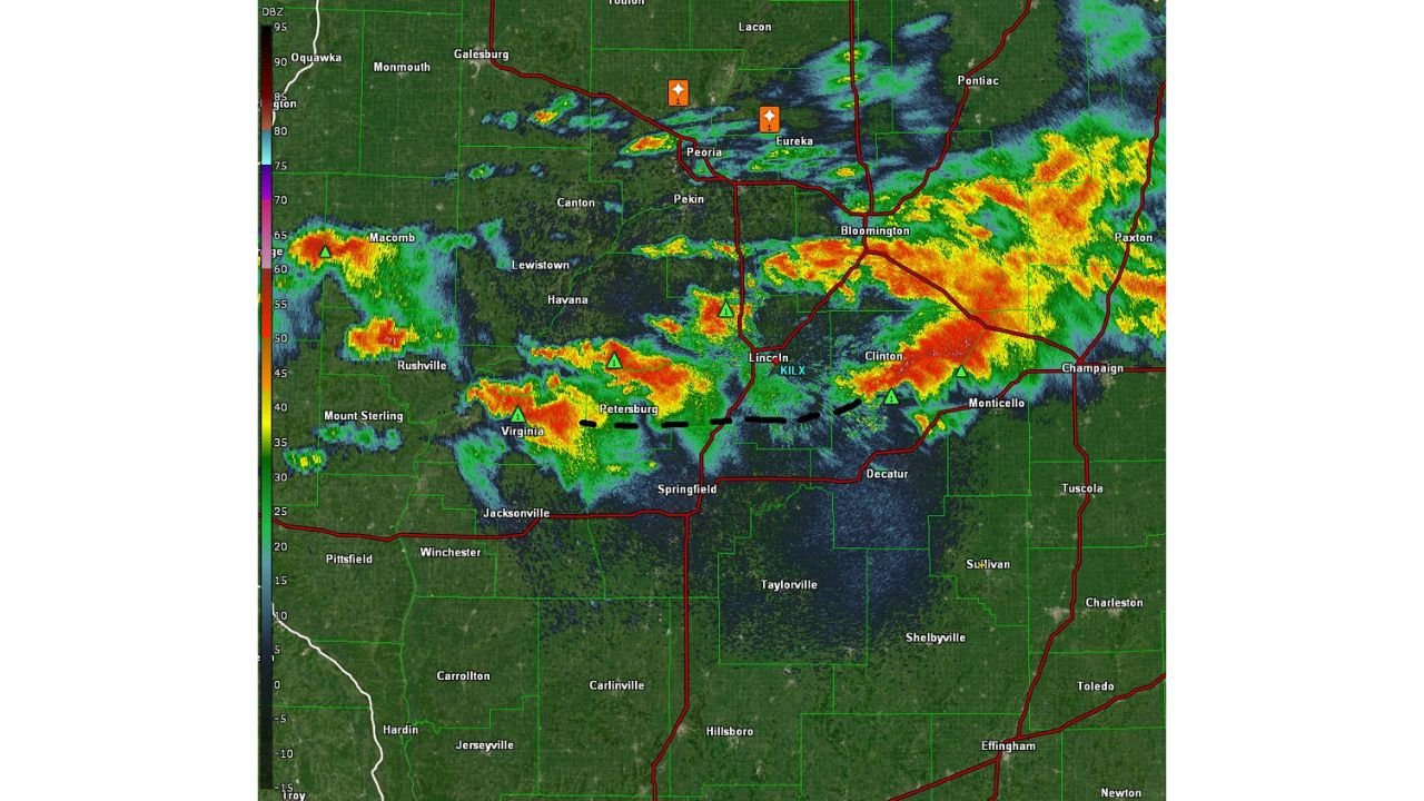
What Is Happening on Radar Right Now
Live radar shows multiple supercell thunderstorms actively developing across central Illinois with the heaviest returns showing up near:
- Peoria and Eureka
- Bloomington and Clinton
- Virginia and Petersburg
- Lincoln and Monticello
- Champaign and Paxton
Storm cells are showing intense red and orange radar returns indicating extremely heavy rainfall and strong rotation developing within multiple storms simultaneously.
The Key Threat Right Now: The Outflow Boundary Near Lincoln
Here is the detail that has forecasters most concerned at this moment. The lead storm kicked out a new outflow boundary (OFB) that is now stalling south of Lincoln, Illinois. This boundary is shown clearly on radar as a dashed line running from near Virginia through Petersburg toward Lincoln, Clinton and Monticello.
This outflow boundary is now parked directly in the path of the supercell near Virginia, Illinois. When a supercell interacts with a stalled outflow boundary like this, it can:
- Dramatically intensify rotation within the storm
- Trigger rapid tornado development with very little warning time
- Produce a strong and long-tracked tornado as the storm feeds off the boundary
This is precisely why forecasters are calling this storm the one to watch right now.
The Storm Near Virginia Illinois Is the One to Watch
The supercell currently near Virginia, Illinois is tracking directly toward this stalled outflow boundary. Forecasters are saying this storm may become the first tornadic supercell of the day. Communities in the direct path of this storm need to be taking shelter right now, including:
- Virginia, Illinois
- Petersburg, Illinois
- Springfield, Illinois
- Jacksonville, Illinois
- Lincoln, Illinois
- Taylorville, Illinois
- Decatur, Illinois
What an Outflow Boundary Interaction Means for You
For residents who are not weather experts, here is what this means in plain terms. An outflow boundary is essentially an invisible trigger line left on the ground by earlier storms. When a new supercell rolls over that boundary, it is like throwing fuel on a fire. Rotation can go from weak to violent in a matter of minutes and a tornado can touch down before a warning is even issued.
This is why you cannot afford to wait for a warning before taking shelter.
Take Action Right Now
If you are anywhere in central Illinois, especially near the communities listed above:
- Get to your shelter immediately, do not wait for a warning
- Go to the lowest floor of a sturdy building away from all windows
- Do not go outside to look at the sky
- Keep weather alerts on and your phone charged
- Stay off all roads as tornadoes can cross highways with no warning
- Monitor live updates at NOAA Storm Prediction Center
The next 30 to 60 minutes are critical. This situation is developing fast and conditions can change from watch to life-threatening warning in minutes.
Want more breaking weather updates and news that affects your community? Visit Bktoday.org for daily updates and never miss a story that matters.