
Expansive Marginal Risk Stretches From the East Coast to Montana on Monday as Mid Atlantic Faces Isolated Tornado Threat Near Washington DC and Philadelphia
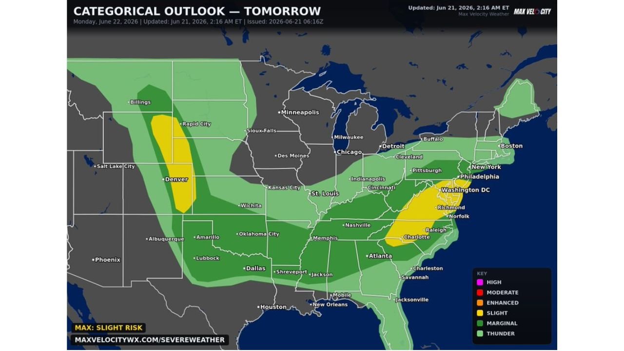
Monday’s severe weather outlook covers an enormous footprint of the United States, with an expansive Level 1 of 5 marginal risk in place stretching from the East Coast all the way through the Deep South and southern Plains, reaching as far west as Billings, Montana. Within that broad zone, two areas of higher confidence stand out, including the only tornado risk currently identified for the day.
Breaking Down Monday’s Risk Levels
According to the categorical outlook updated at 2:16 AM ET on June 21 and valid for Monday June 22, 2026, the severe weather threat is broken into the following zones:
Marginal Risk Level 1 (Light Green Zone): This is by far the most widespread category today, stretching from the East Coast down through the Deep South and southern Plains, and extending all the way out to Billings, Montana. This zone covers cities including Boston, New York, Pittsburgh, Indianapolis, St. Louis, Memphis, Dallas, Atlanta, and Houston.
Slight Risk Level 2 (Yellow Zone): Two separate areas have been highlighted where forecasters have higher confidence in severe storms developing:
- The Mid-Atlantic, covering Washington DC, Philadelphia, Richmond, Norfolk and Charlotte
- The central High Plains, covering Rapid City and areas near Denver
The Only Tornado Risk Today Is in the Mid-Atlantic
For Monday, the sole tornado risk identified anywhere in the country is centered over the Mid-Atlantic region. Forecasters say isolated tornadoes are possible in the afternoon within this zone, which specifically includes:
- Washington DC
- Philadelphia
- Richmond, Virginia
- Norfolk, Virginia
- Charlotte, North Carolina
While the tornado threat is described as isolated, meaning only a small number of tornadoes are expected if any develop at all, residents in these specific metro areas should still stay weather aware through the afternoon hours given the elevated confidence level forecasters have assigned to this zone.
What’s Happening in the Central High Plains
The second area of elevated concern sits over the central High Plains, particularly near Rapid City and the Denver area. While this zone does not carry a tornado threat, the higher slight risk designation indicates forecasters have greater confidence in severe thunderstorms developing here, likely bringing threats such as damaging winds and large hail.
A Quieter Day Compared to the Weekend
Monday’s outlook represents a notable step down in intensity compared to the tornado outbreak and flooding concerns that were dominating forecasts for Sunday across Missouri, Illinois and Indiana. The marginal risk designation covering most of the country indicates that while scattered storms are possible across a very wide area, the overall severity and organization of Monday’s storms is expected to be considerably lower than what the central US experienced over the weekend.
Who Should Stay Weather Aware Monday
Given the broad marginal risk zone, residents across a huge portion of the country should keep half an eye on the forecast, but the areas requiring the closest attention are:
- Washington DC and Philadelphia (isolated tornado risk)
- Richmond, Norfolk and Charlotte (isolated tornado risk)
- Rapid City and Denver area (higher confidence severe storms, primarily wind and hail)
Staying Prepared
Even on lower risk days like Monday, it remains worth keeping basic precautions in place, especially for those in the slight risk zones:
- Keep weather alerts active on your phone, particularly if you are in the Mid-Atlantic or central High Plains zones
- Avoid outdoor activities during peak afternoon storm hours if skies begin to darken
- Have a shelter plan ready, even for isolated tornado risks, since these storms can develop quickly
- Monitor updates through the NOAA Storm Prediction Center
Monday’s forecast is far less severe than the weekend’s outbreak, but the isolated tornado risk in the Mid-Atlantic means residents there should not completely let their guard down.
Want more breaking weather updates and news that affects your community? Visit Bktoday.org for daily updates and never miss a story that matters.