
Destructive Line of Storms With 80 mph Winds Already Moving Through Illinois Right Now as Severe Bowing Segment Targets Chicago, Bloomington and Beyond
A destructive line of severe storms is actively moving through Illinois this morning, bringing 80+ mph destructive winds, isolated large hail, and embedded tornadoes. Radar as of 7:55 AM CDT on June 17, 2026 shows the system already well underway and pushing eastward fast.
What Is a Bowing Segment and Why Is It Dangerous
A severe bowing segment is one of the most dangerous configurations a storm system can take. It forms when a line of thunderstorms bows outward due to extremely powerful winds pushing from behind. The result is a concentrated zone of devastating straight-line winds that can cause destruction comparable to a tornado, snapping trees, flattening structures, and leaving widespread power outages in its path.
This morning’s bowing segment is already producing winds exceeding 80 mph and the threat includes:
- 80+ mph destructive straight-line winds
- Isolated large hail
- Embedded tornadoes within the line
Exact Timing of When the Storm Hits Your Area
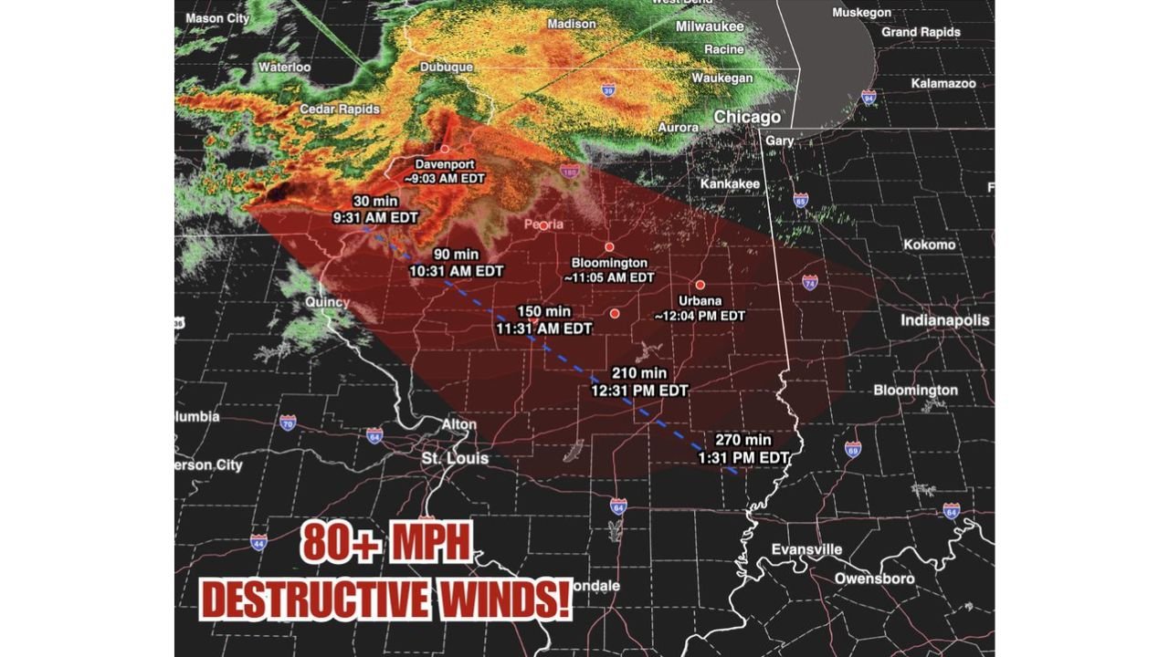
According to the BAM Weather radar timing map, here is when the severe bowing segment is expected to reach key locations. Note that times below are in EDT, subtract 1 hour for CDT:
- Davenport: Already hit around 9:03 AM EDT
- 30 minutes mark: 9:31 AM EDT
- 90 minutes mark: 10:31 AM EDT
- Bloomington: Around 11:05 AM EDT
- 150 minutes mark: 11:31 AM EDT
- Urbana: Around 12:04 PM EDT
- 210 minutes mark: 12:31 PM EDT
- 270 minutes mark: 1:31 PM EDT
The storm system is moving southeast, meaning communities from Peoria and Bloomington down toward Alton, St. Louis and into southern Illinois are all in the direct path throughout the late morning and early afternoon hours.
Cities Currently in the Path
Based on the radar imagery, the following areas are directly in the path of this destructive line:
- Chicago and surrounding suburbs (Aurora, Waukegan, Kankakee)
- Bloomington and Peoria
- Urbana and Champaign
- Quincy and Alton
- Areas toward St. Louis and Evansville
This Is Just the Morning Round
It is critical to understand that this morning’s storm line is only the first round of today’s severe weather. As reported earlier, the Storm Prediction Center has issued a Level 4 of 5 outbreak for Illinois and Indiana today, with the most dangerous window expected to arrive around 5 PM this evening when atmospheric conditions become even more favorable for strong and long-tracked tornadoes.
Residents should not let the morning storms cause them to let their guard down for the rest of the day.
What You Should Do Right Now
If you are in the path of this storm line:
- Take shelter immediately in an interior room on the lowest floor of a sturdy building
- Stay away from windows
- Do not drive through the storm as 80+ mph winds can flip vehicles
- Keep your phone charged and weather alerts turned on
- Monitor updates from the NOAA Storm Prediction Center in real time
This is an extremely dangerous and life-threatening situation. Do not wait for a warning to take action.
Want more breaking weather updates and news that affects your community? Visit Bktoday.org for daily updates and never miss a story that matters.