
Two Separate Rounds of Tornado Potential Expected Tomorrow Across Southern Illinois as Forecasters Warn of an Impactful Severe Weather Holiday
Forecasters are warning that tomorrow could bring two distinct rounds of tornado potential across southern Illinois and surrounding areas, setting up what one meteorologist described as a potentially impactful severe weather event on a holiday. Residents in the region are being urged to stay weather aware throughout the entire day rather than letting their guard down after just one round of storms passes.
Round One: The Afternoon MCV Threat
The first wave of severe weather is expected during the afternoon hours, when a Mesoscale Convective Vortex (MCV) is forecast to move through the region. This system is expected to bring:
- A damaging wind threat
- Embedded mini supercells
- Tornado potential within those embedded supercells
This same atmospheric setup is also expected to bring a tornado risk to areas around St. Louis and eastern Missouri during the same afternoon timeframe, meaning the threat extends well beyond just Illinois.
Round Two: A More Discrete Evening Threat
If the atmosphere is able to recover properly after the first round moves through, forecasters say a second and more discrete round of storms is likely to develop during the evening hours. This second round carries the potential for:
- Large hail
- Damaging winds
- Additional tornado potential
Forecasters note this evening round is expected to produce more classic, isolated supercell structures rather than the broader complex expected during the afternoon, which is part of why storm chasers are specifically targeting this window.
Where the Evening Round Could Set Up
The exact location of the evening round remains to be determined, but current forecast models including the HRRR and other convection allowing models suggest the most likely target areas are:
- Southern Illinois
- Southern Indiana
- Potentially northwest Kentucky
Forecasters caution that the final placement will largely depend on how the afternoon MCV evolves, meaning the evening setup could shift depending on what happens earlier in the day.
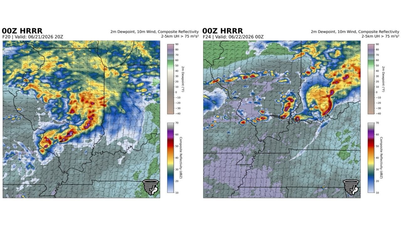
What the Forecast Models Are Showing
The HRRR model imagery, valid for 6 PM and 7 PM CDT on June 21, 2026, shows two separate snapshots of developing storm activity:
The first panel (Valid 06/21/2026 20Z) shows an intense and well organized line of storms with high reflectivity values shown in red and purple stretching across southern Illinois and into Indiana, indicating strong to severe storm intensity already established by that point in the afternoon.
The second panel (Valid 06/22/2026 00Z) shows the atmosphere evolving further into the evening, with multiple separate cells showing strong reflectivity signatures scattered across the region, consistent with the more discrete supercell setup forecasters are expecting later in the day.
Both panels also display updraft helicity values exceeding 75 m²/s² in localized areas, a metric meteorologists use to identify regions of strong rotation within storms, reinforcing the tornado potential within both rounds.
A Severe Weather Day Falling on a Holiday
Forecasters are specifically flagging that this severe weather potential is developing on a holiday, when many people may be outdoors, traveling, or away from their usual sources of weather information. This timing adds an extra layer of risk, since holiday plans can sometimes mean people are less prepared or less attentive to changing weather conditions than they might be on a typical day.
Areas That Should Stay Weather Aware Tomorrow
Based on current forecasts, the following areas should pay close attention throughout the entire day, not just during one round of storms:
- Southern Illinois
- St. Louis, Missouri and eastern Missouri
- Southern Indiana
- Northwest Kentucky
How to Prepare for a Two Round Severe Weather Day
Because tomorrow’s threat is expected to come in two separate waves, residents should avoid assuming the danger has passed after the first round moves through. Recommended precautions include:
- Have your shelter plan ready for both the afternoon and evening hours
- Keep weather alerts active throughout the entire day
- Avoid letting your guard down after the first round of storms passes, since the evening round may bring renewed tornado potential
- Adjust holiday plans if storms are actively developing near your location
- Monitor real time updates through the NOAA Storm Prediction Center
With two separate rounds of tornado potential in play and forecasters openly comparing this to a potentially impactful severe weather event, residents across southern Illinois and the surrounding tri-state area should treat tomorrow as a day requiring continuous weather awareness from morning through night.
Want more breaking weather updates and news that affects your community? Visit Bktoday.org for daily updates and never miss a story that matters.