
SPC Issues Urgent Update as Locally Enhanced Strong Tornado Threat Shifts South Tonight Targeting Springfield, Bloomington, Indianapolis and Surrounding Communities
A locally enhanced strong tornado threat is now in place for tonight across a broad swath of the Midwest as the Storm Prediction Center has shifted its outlook southward, a development that forecasters predicted six hours ago. The evening hours are shaping up to be the most dangerous window of this entire outbreak and residents across the affected zone need to have their plans ready right now.
What Has Changed in the Last Few Hours
The SPC outlook has shifted south from where the highest risk was originally drawn this morning. This southward shift is significant because it means communities that may have thought they were on the edge of the threat are now sitting directly inside the highest risk corridor for tonight.
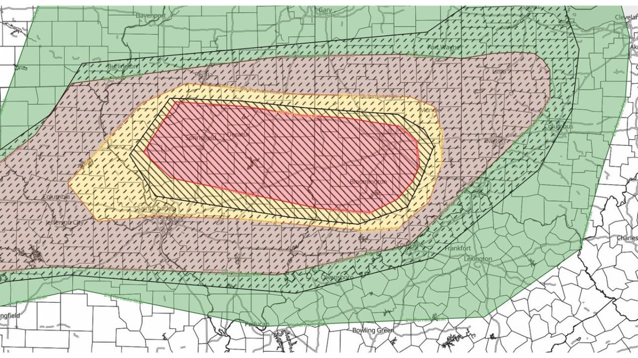
The updated tornado probability map now shows three distinct risk zones for tonight:
- High Risk Inner Core Zone (Red with hatching): The most dangerous corridor running through central Illinois and into Indiana, covering areas including Springfield, Decatur, Bloomington Indiana and surrounding communities. This zone carries the highest probability of strong and violent tornadoes tonight.
- Elevated Risk Zone (Yellow with hatching): A broader surrounding area extending from near Davenport and Burlington in the north down through Columbia, Jefferson City and St. Louis in the south and east toward Fort Wayne, Lima and Columbus in Indiana and Ohio.
- General Tornado Risk Zone (Purple/Pink hatching): The widest zone covering an enormous footprint from Gary and Davenport in the north all the way down toward Paducah, Bowling Green and Owensboro in the south and reaching toward Cleveland and Columbus in the east.
Why Tonight Is So Dangerous
The hatching pattern on the tornado probability map is critically important. Hatching indicates the risk of significant tornadoes rated EF2 or stronger. The fact that hatching covers both the red core zone and the yellow elevated zone means forecasters are not just expecting tornadoes tonight. They are expecting violent and potentially long-tracked tornadoes capable of causing catastrophic damage.
Key factors driving tonight’s extreme threat:
- Locally enhanced kinematics creating ideal conditions for tornado development
- Airmass fully recovered after this morning’s storms, reloading the atmosphere with dangerous energy
- Strong low level wind shear supporting long-tracked supercells
- The southward shift placing new communities directly in the highest risk zone
Communities in the Direct Path Tonight
Based on the updated outlook map, these areas face the most serious tornado threat this evening:
- Springfield, Illinois
- Decatur, Illinois
- Bloomington, Indiana
- Indianapolis, Indiana
- Terre Haute, Indiana
- Frankfort, Kentucky
- Lexington, Kentucky
- Owensboro, Kentucky
- Paducah, Kentucky
- Columbia, Missouri
- Jefferson City, Missouri
Have a Plan Before 5 PM EDT
Tonight’s severe weather coverage begins at 5 PM EDT. Do not wait until then to make your plan. Every minute matters when tornadoes are on the ground.
Here is what you need to do right now:
- Identify your shelter location on the lowest floor of a sturdy building
- Charge all devices and power banks immediately
- Download a weather alert app if you do not already have one
- Discuss your plan with your family including where to meet and what to do
- Stay indoors once storms begin moving through your area
- Do not attempt to drive away from a tornado warning
- Monitor real time updates at NOAA Storm Prediction Center
Tonight’s outbreak is far from over. The most dangerous storms of the day are still ahead and the window from this evening through tonight is when the highest risk of violent tornadoes exists across this region.
Want more breaking weather updates and news that affects your community? Visit Bktoday.org for daily updates and never miss a story that matters.