
Airmass Recovery Now Underway Across Central Illinois as Outflow Boundary Sets the Stage for Intense Tornadoes This Afternoon
The morning storm complex has cleared but the danger is far from over. As of 12:40 PM CDT on Wednesday June 17, airmass recovery is actively underway behind this morning’s batch of storms and forecasters are now warning that the atmosphere is rapidly destabilizing ahead of what could be the most dangerous window of the entire day.
What Is Happening Right Now
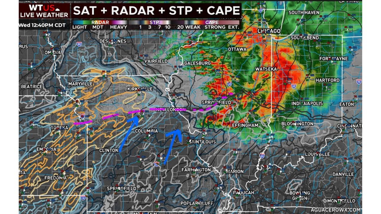
Live radar as of 12:40 PM CDT shows heavy storm activity already firing across areas near Chicago, Ottawa, Watseka and Springfield in Illinois, with the system pushing toward Fort Wayne, South Bend and Indianapolis in Indiana.
Here is the current atmospheric setup that has forecasters concerned:
- Airmass recovery is underway behind this morning’s storms
- A well defined East to West oriented boundary is currently in place
- Mostly cloudy skies on the cool side of the boundary are suppressing destabilization in the short term
- However, strong mass response is pulling warm and moist air northward
- The airmass is expected to fully destabilize within the next couple of hours
The Most Dangerous Detail Right Now
This morning’s storm complex left behind something that forecasters are watching very closely. It laid out an outflow boundary across parts of Central Illinois and that boundary could become a focal point for intense tornadoes this afternoon.
Outflow boundaries are essentially invisible trigger lines left behind by storms. When new supercells interact with these boundaries, they can rapidly intensify and produce strong long-tracked tornadoes with very little warning time.
What the Radar Is Showing
The live SAT plus RADAR plus STP plus CAPE map from AguaceroWx at 12:40 PM CDT shows:
- Extreme CAPE values shown in deep red and orange across central and eastern Illinois, indicating a highly unstable atmosphere loaded with energy for severe storm development
- High STP (Significant Tornado Parameter) values of 7 to 10 and above across the most dangerous zones, meaning the environment is primed for significant tornadoes
- Heavy radar returns already showing active storm cells near Springfield, Effingham, Watseka and pushing toward the Indiana border
- The outflow boundary clearly visible as a focal trigger zone across Central Illinois
Cities That Need to Be on High Alert Right Now
Based on the current radar and atmospheric setup, the following areas face the most immediate and serious threat this afternoon:
- Springfield, Illinois
- Effingham, Illinois
- Watseka, Illinois
- Ottawa, Illinois
- Galesburg, Illinois
- Fort Wayne, Indiana
- Indianapolis, Indiana
- Bloomington, Indiana
- South Bend, Indiana
The Next Few Hours Are Critical
The current cloud cover on the cool side of the boundary is temporarily holding things back, but that suppression will not last. As warm moist air continues to surge northward over the next couple of hours, the atmosphere will destabilize rapidly and new supercells will have everything they need to produce intense and long-tracked tornadoes.
This is the window forecasters have been warning about all day.
Do Not Let Your Guard Down
If you are in central Illinois or western Indiana right now, this is not the time to step outside or get back on the roads. Take the following steps immediately:
- Get to your safe shelter now on the lowest floor away from windows
- Keep your weather alerts active on your phone at all times
- Stay off the roads as tornado warnings could be issued with little notice
- Check on neighbors and family who may not be aware of how serious this afternoon is
- Monitor real time updates at NOAA Storm Prediction Center
The most dangerous hours of this outbreak are still ahead. Stay safe and stay sheltered.
Want more breaking weather updates and news that affects your community? Visit Bktoday.org for daily updates and never miss a story that matters.