
Severe Weather Outbreak Declared for Illinois and Indiana Today as SPC Issues Rare Level 4 of 5 Warning With Strong Tornadoes, 75 mph Winds and Large Hail All on the Table
The Storm Prediction Center (SPC) has issued a Level 4 of 5 severe weather outbreak for portions of Illinois and Indiana today, Wednesday June 17, 2026, and the word forecasters are using is outbreak. This is one of the most serious severe weather setups the region has seen this season and residents are being urged to take shelter and stay weather aware all day long.
What the SPC Is Warning About
An outbreak of severe thunderstorms is expected today, with the primary threat centered over Illinois and Indiana. Several intense tornadoes, swaths of damaging gusts over 75 mph, and damaging wind-driven hail are all possible.
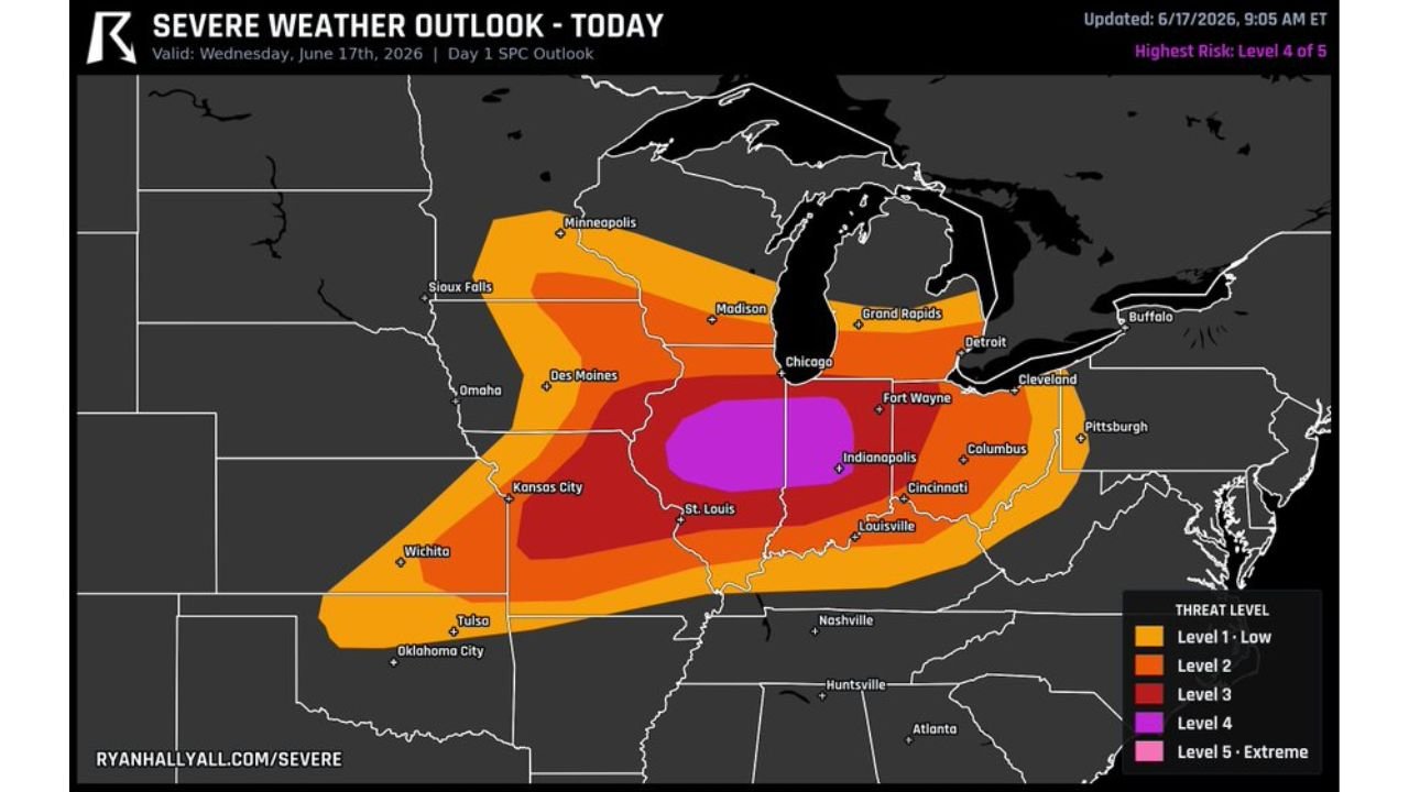
According to the severe weather outlook map updated at 9:05 AM ET on June 17, the highest risk zone sitting at Level 4 shown in purple covers central Illinois and into Indiana, including areas near Chicago, Indianapolis, Fort Wayne, and St. Louis.
What Is Already Happening
A storm cluster over Iowa already clocked a 94 mph gust before sunrise this morning. That same dangerous energy is now sliding directly toward Illinois. As the air recovers behind it through the afternoon, conditions are expected to become increasingly dangerous.
Forecasters warn that if this system delivers like it looks, the most severe activity will likely arrive around 5 PM this evening.
The Threats on the Table Today
Here is what residents across the affected region need to prepare for:
- Strong and intense tornadoes including potential EF-3 or stronger
- Damaging wind gusts exceeding 75 mph
- Large hail up to 2.5 inches in diameter
- Flash flooding in certain areas
- Widespread and long-lasting power outages
This Region Has Already Been Hit Hard
The National Weather Service has confirmed at least 17 tornadoes across Illinois and Indiana from last week’s severe weather outbreak alone. Two EF-3 tornadoes were confirmed in Streator, Illinois and Kouts, Indiana, while several other tornadoes ranged from EF-0 to EF-2 strength.
In Illinois alone, the preliminary count of tornadoes for 2026 is 145, compared to 147 finalized for all of last year. Last year’s Illinois tornado count was higher than any year since 1950.
This means today’s outbreak is hitting a region that is already storm weary and in recovery mode.
What Is Driving This Outbreak
The driving force behind today’s elevated threat is an abnormally strong jet streak roaring into the Illinois and Indiana region, combining with potent summertime instability to create an environment capable of supporting multiple significant and intense tornadoes. The initiating boundary is expected to be a pre-frontal trough rather than a sweeping cold front, a critical distinction that will allow storms to remain dangerously discrete and fast-moving for a 3 to 4 hour window.
Who Is Most at Risk
The severe weather outlook map shows the following threat zones today:
- Level 4 (Purple) Extreme Core Zone: Central Illinois into Indiana, including areas near Indianapolis and Fort Wayne
- Level 3 (Red) High Risk Zone: Broader area covering Chicago, St. Louis, Columbus and surrounding regions
- Level 2 (Orange) Elevated Risk Zone: Extends outward toward Minneapolis, Kansas City, Detroit and Pittsburgh
What You Should Do Right Now
The National Weather Service is urging everyone in the affected areas to:
- Know where your safest shelter is before any warning is issued
- Make sure your safe space is ready
- Have flashlights, batteries and portable charging packs ready to go
- Stay weather aware all day long and not just during the evening hours
- Monitor updates from the NOAA Storm Prediction Center throughout the day
Do not wait for a warning to be issued before taking action. With a system this powerful, conditions can deteriorate rapidly and without much notice.
Want more breaking news and weather updates that affect your community? Visit Bktoday.org for daily updates and never miss a story that matters.