
Forecast Models Finally Agree on Discrete Supercell Mode Across the High Plains Tomorrow as Southern Illinois Faces Enhanced Tornado Potential From Rapid Upscale Growth
A significant shift in the forecast is taking shape for Tuesday June 23, 2026, as forecast models have finally come into agreement on a setup that could bring discrete supercell thunderstorms up and down the high Plains, while simultaneously setting the stage for enhanced tornado potential in southern Illinois through a process called rapid upscale growth.
What the Models Are Now Showing
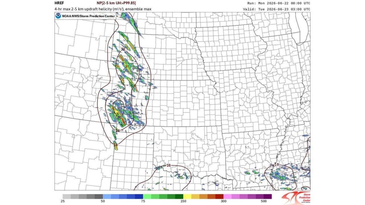
According to the latest HREF ensemble forecast from the NOAA National Weather Service Storm Prediction Center, valid for Tuesday June 23 at 3:00 AM UTC, the 4-hour maximum updraft helicity map shows a concentrated corridor of extremely high rotation values stretching along the high Plains, with the most intense values, shown in yellow, orange and red on the map, concentrated in the southern portion of the zone.
The updraft helicity values exceeding 150 to 300 m²/s² in portions of the highlighted corridor represent an atmosphere that is primed and capable of supporting strong rotating updrafts, which is exactly the type of environment that produces significant and long-tracked tornadoes.
What Discrete Supercell Mode Means
For weeks, forecast models have struggled to consistently show discrete supercell mode for upcoming setups, instead showing messy and less organized storm structures. The fact that most convection allowing models (CAMs) are finally agreeing on an explicitly discrete supercell setup for tomorrow is a meaningful and important signal.
A discrete supercell is a single, isolated, and highly organized thunderstorm that is not competing with surrounding storm activity for atmospheric energy. These storms are considered the most tornado-capable storm type in existence because they can maintain strong rotation for extended periods without interference from neighboring storms.
Why Southern Illinois Faces Enhanced Tornado Potential
Here is where the forecast gets more complex and concerning for southern Illinois. Forecasters are warning of a process called rapid upscale growth, which occurs when discrete supercells eventually merge and grow into a larger, more disorganized storm complex.
This transition is significant for southern Illinois because:
- Discrete supercells firing on the high Plains will track eastward
- As they move, they may begin to interact and merge through the upscale growth process
- This merger can produce enhanced tornado potential along the leading edge of the growing storm complex
- Southern Illinois sits in the zone where this transition is most likely to occur based on current model data
- A stratus layer developing in the region could also play a role in how storms organize and intensify as they move into the area
What the Updraft Helicity Map Is Telling Us
The HREF ensemble map showing 4-hour maximum updraft helicity values is one of the most reliable tools forecasters use to identify areas at risk for significant tornadoes. The fact that this map shows:
- Values exceeding 300 m²/s² in the core of the high Plains corridor
- A second separate area of elevated helicity across portions of the south
- The 99.85th percentile threshold being exceeded across the primary risk zone
All of this points toward a setup that warrants serious attention heading into Tuesday.
Areas to Watch Closely Tomorrow
Based on the current forecast data, the following areas should begin monitoring Tuesday’s developing severe weather situation closely:
- Southern Illinois and the surrounding tri-state area
- High Plains corridor from the Nebraska and Kansas border southward
- Areas along the projected storm track as discrete supercells move eastward through the day
Stay Ahead of This Developing Situation
With models now in stronger agreement on the setup and updraft helicity values already showing alarming potential in the ensemble data, residents across the highlighted zones should begin preparing now rather than waiting for Tuesday morning. Monitor updates closely through the NOAA Storm Prediction Center as this forecast continues to evolve over the next 24 hours.
Want more breaking weather updates and news that affects your community? Visit Bktoday.org for daily updates and never miss a story that matters.