
Eastern Kentucky and Eastern Ohio Facing Another Round of Strong to Severe Storms This Afternoon and Evening With Damaging Wind Gusts and a Low End Tornado Risk
Eastern Kentucky and Eastern Ohio are bracing for another round of strong to severe thunderstorms this afternoon and evening on Monday June 22, 2026, as a cold front pushes through the region. While much of the surrounding area will see a relatively quieter afternoon, the eastern portions of both states face a real severe weather threat before the day is done.
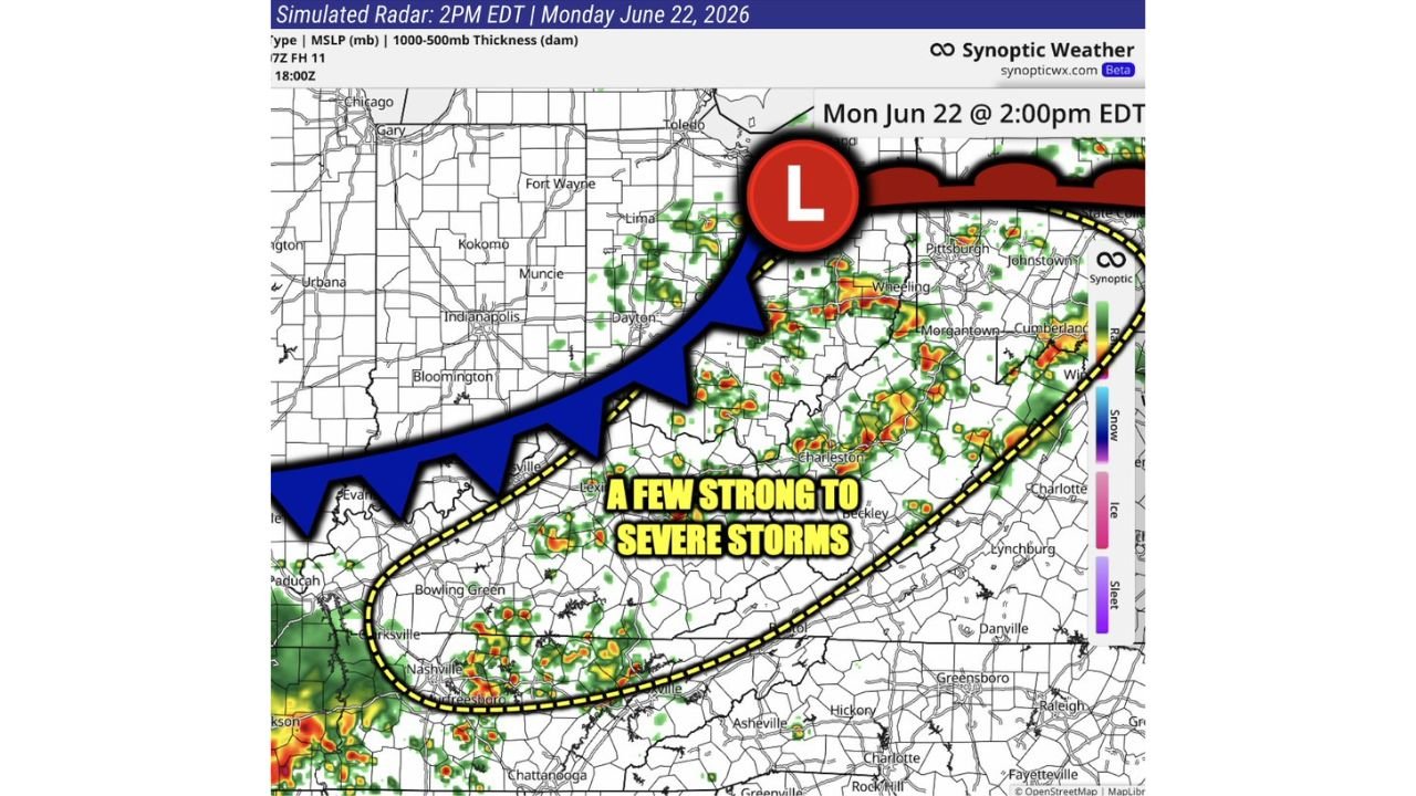
What the Forecast Is Showing for This Afternoon
According to the BAM Weather simulated radar, valid for 2 PM EDT on Monday June 22, a cold front is clearly visible sweeping through the region, with storm activity already firing along and ahead of the boundary across eastern Kentucky, eastern Ohio, West Virginia and surrounding areas.
The yellow dashed zone on the forecast map highlights the area where a few strong to severe storms are expected to develop during the afternoon and evening hours.
The Primary Threats Today
Forecasters have outlined the following hazards for eastern Kentucky and eastern Ohio this afternoon and evening:
- Strong to severe wind gusts as the primary and most widespread threat
- A very low end tornado risk that cannot be completely ruled out across the affected areas
- Heavy rainfall with some storm cells showing intense radar returns
Who Is in the Bullseye Today
Based on the simulated radar and storm track, the following communities fall within the highlighted severe weather corridor:
- Eastern Kentucky including Lexington, Beckley area, and surrounding communities
- Eastern Ohio including areas near Dayton, Wheeling and Morgantown
- West Virginia including Charleston and Cumberland
- Western portions of Virginia and North Carolina including Danville, Lynchburg and surrounding areas
What the Rest of the Region Can Expect
For areas north of the primary threat zone, forecasters say it should be a quieter afternoon overall, with only some isolated sprinkles and scattered light showers possible but nothing organized or severe expected.
This means cities like Chicago, Indianapolis, Fort Wayne and Toledo are largely in the clear for today’s afternoon hours, though light rain remains possible.
Stay Weather Aware This Afternoon and Evening
Even though today’s threat is described as low end compared to the weekend’s major outbreak, a low end tornado risk and severe wind gusts are still capable of causing real damage and dangerous conditions. Residents across eastern Kentucky and eastern Ohio should:
- Keep weather alerts active on their phones through the evening hours
- Stay aware of rapidly changing conditions as the cold front pushes through
- Avoid being caught outdoors during any actively developing storms
- Have a shelter plan ready even for a low end tornado risk, since isolated tornadoes can still develop with little warning
- Monitor real time updates through the NOAA Storm Prediction Center
Today’s threat is significantly lower in intensity compared to the major severe weather events that impacted the central United States over the weekend, but residents across the highlighted corridor should still take the afternoon storm risk seriously.
Want more breaking weather updates and news that affects your community? Visit Bktoday.org for daily updates and never miss a story that matters.