
Strong Tornado Potential Targets Southern Illinois Today as Forecasters Identify a Peak Threat Window Between 2 PM and 9 PM Across St. Louis, Springfield and Evansville
Forecasters have identified an area of strong tornado potential across southern Illinois today, with a clearly defined corridor stretching across multiple states where conditions could become favorable for isolated supercells capable of producing strong tornadoes. The highlighted risk zone covers a wide swath of the region, and forecasters are urging residents to remain weather aware throughout the entire afternoon and evening.
The Peak Threat Window Today
According to today’s outlook, the highlighted area on the map carries the greatest potential for a strong tornado specifically between 2 PM and 9 PM. This seven hour window represents the period when conditions are most likely to come together for dangerous storm development.
Forecasters note that the outcome today will largely depend on how this morning’s storms evolve. If sufficient clearing occurs and daytime heating is allowed to build through the early afternoon, the atmosphere could become primed for isolated supercells capable of producing strong tornadoes.
The Three Primary Threats Today
Forecasters have outlined three specific hazards residents in the highlighted zone need to prepare for:
- Strong tornadoes
- Very large hail
- Damaging winds
This combination of threats means today carries the potential for multiple types of severe weather damage simultaneously, not just a tornado risk alone.
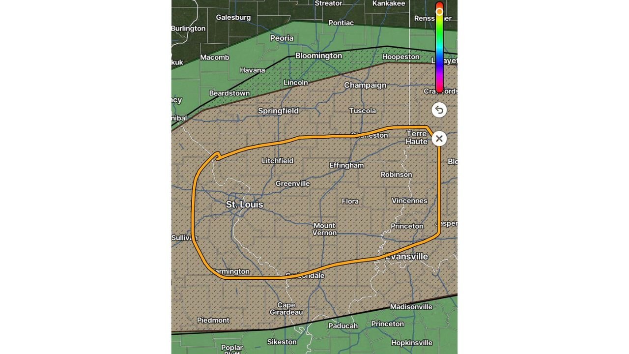
The Exact Area Under the Highest Risk
The highlighted corridor on today’s map covers an extensive area stretching across central and southern Illinois and into parts of Missouri, Indiana and Kentucky. Communities falling within this highest risk zone include:
- St. Louis, Missouri
- Springfield, Illinois
- Bloomington, Illinois
- Champaign, Illinois
- Effingham, Illinois
- Mount Vernon, Illinois
- Carbondale, Illinois
- Terre Haute, Indiana
- Evansville, Indiana
- Vincennes, Indiana
- Paducah, Kentucky
The hatched pattern visible across this entire zone on the map indicates the area where forecasters have the highest confidence in significant tornado potential, reinforcing that this is not a minor or isolated concern but a broad regional threat.
Why Today’s Timing Matters
The fact that forecasters have pinned down such a specific window, 2 PM to 9 PM, gives residents a clear timeframe to plan around. This is the period when the combination of morning storm clearing, daytime heating, and atmospheric instability is expected to align most favorably for dangerous supercell development.
Residents should treat the hours leading up to 2 PM as preparation time and remain especially alert once that window begins, continuing to monitor conditions closely through 9 PM when the threat is expected to gradually diminish.
Conditions Are Still Evolving
Forecasters have been clear that today’s outlook will continue to evolve as the morning progresses, particularly depending on how this morning’s storm activity clears out and how much daytime heating actually materializes. Residents are encouraged to stay tuned for updates throughout the day rather than relying solely on this morning’s outlook.
What Residents Across the Highlighted Zone Should Do
With a clearly defined peak threat window and a wide area covered by the highest risk corridor, residents across southern Illinois and the surrounding tri-state region should take the following steps before the 2 PM window begins:
- Finalize your shelter plan now, before storms begin developing
- Charge all devices and weather radios
- Keep weather alerts active throughout the entire 2 PM to 9 PM window
- Avoid unnecessary travel through the highlighted corridor during peak hours if possible
- Continue checking for updated outlooks as morning storm activity clears
- Monitor real time conditions through the NOAA Storm Prediction Center
With strong tornadoes, very large hail, and damaging winds all on the table for today, residents across the highlighted corridor should treat this as a serious and actionable threat throughout the entire afternoon and evening.
Want more breaking weather updates and news that affects your community? Visit Bktoday.org for daily updates and never miss a story that matters.